Environment-Clean-Generations

Environment-Clean-Generations
THE DEFINITIVE BLOG FOR EVERYTHING YOU NEED TO KNOW ABOUT THE ENVIRONMENT YOU LIVE IN, WITH REFERENCE TO LIFE, EARTH AND COSMIC SPACE SCIENCES, PRESENTED BY ENVIRONMENTAL ENGINEER DORU INDREI, ENVIRONMENTAL QUALITY AND ENERGY SPACIALIST
"Life is not about what we know, but what we don't know, craving the unthinkable makes it so amazing, that is worth dying for." Doru Indrei
Custom Search
Showing posts with label sea. Show all posts

The Methane Time Bomb


Arctic scientists discover new global warming threat as melting permafrost releases millions of tons of a gas 20 times more damaging than carbon dioxide 

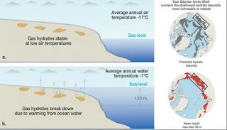
 The first evidence that millions of tons of a greenhouse gas 20 times more potent than carbon dioxide is being released into the atmosphere from beneath the Arctic seabed has been discovered by scientists.

The Independent has been passed details of preliminary findings suggesting that massive deposits of sub-sea methane are bubbling to the surface as the Arctic region becomes warmer and its ice retreats.

Underground stores of methane are important because scientists believe their sudden release has in the past been responsible for rapid increases in global temperatures, dramatic changes to the climate, and even the mass extinction of species. Scientists aboard a research ship that has sailed the entire length of Russia's northern coast have discovered intense concentrations of methane – sometimes at up to 100 times background levels – over several areas covering thousands of square miles of the Siberian continental shelf.


In the past few days, the researchers have seen areas of sea foaming with gas bubbling up through "methane chimneys" rising from the sea floor. They believe that the sub-sea layer of permafrost, which has acted like a "lid" to prevent the gas from escaping, has melted away to allow methane to rise from underground deposits formed before the last ice age.
They have warned that this is likely to be linked with the rapid warming that the region has experienced in recent years.

Methane is about 20 times more powerful as a greenhouse gas than carbon dioxide and many scientists fear that its release could accelerate global warming in a giant positive feedback where more atmospheric methane causes higher temperatures, leading to further permafrost melting and the release of yet more methane.
The amount of methane stored beneath the Arctic is calculated to be greater than the total amount of carbon locked up in global coal reserves so there is intense interest in the stability of these deposits as the region warms at a faster rate than other places on earth.
..........................................................................................................................................................
...........................................................................................................................................................

Orjan Gustafsson of Stockholm University in Sweden, one of the leaders of the expedition, described the scale of the methane emissions in an email exchange sent from the Russian research ship Jacob Smirnitskyi.
"We had a hectic finishing of the sampling programme yesterday and this past night," said Dr Gustafsson. "An extensive area of intense methane release was found. At earlier sites we had found elevated levels of dissolved methane. Yesterday, for the first time, we documented a field where the release was so intense that the methane did not have time to dissolve into the seawater but was rising as methane bubbles to the sea surface. These 'methane chimneys' were documented on echo sounder and with seismic [instruments]."

At some locations, methane concentrations reached 100 times background levels. These anomalies have been seen in the East Siberian Sea and the Laptev Sea, covering several tens of thousands of square kilometres, amounting to millions of tons of methane, said Dr Gustafsson. "This may be of the same magnitude as presently estimated from the global ocean," he said. "Nobody knows how many more such areas exist on the extensive East Siberian continental shelves.


"The conventional thought has been that the permafrost 'lid' on the sub-sea sediments on the Siberian shelf should cap and hold the massive reservoirs of shallow methane deposits in place. The growing evidence for release of methane in this inaccessible region may suggest that the permafrost lid is starting to get perforated and thus leak methane... The permafrost now has small holes. We have found elevated levels of methane above the water surface and even more in the water just below. It is obvious that the source is the seabed."
The preliminary findings of the International Siberian Shelf Study 2008, being prepared for publication by the American Geophysical Union, are being overseen by Igor Semiletov of the Far-Eastern branch of the Russian Academy of Sciences. Since 1994, he has led about 10 expeditions in the Laptev Sea but during the 1990s he did not detect any elevated levels of methane. However, since 2003 he reported a rising number of methane "hotspots", which have now been confirmed using more sensitive instruments on board the Jacob Smirnitskyi.

Dr Semiletov has suggested several possible reasons why methane is now being released from the Arctic, including the rising volume of relatively warmer water being discharged from Siberia's rivers due to the melting of the permafrost on the land.
The Arctic region as a whole has seen a 4C rise in average temperatures over recent decades and a dramatic decline in the area of the Arctic Ocean covered by summer sea ice. Many scientists fear that the loss of sea ice could accelerate the warming trend because open ocean soaks up more heat from the sun than the reflective surface of an ice-covered sea.

Arctic Sea Ice Maximum Extent


Sea ice cover in the Arctic appears to have reached its maximum extent for the year, and according to scientists with the National Snow and Ice Data Center, that extent ties 2006 for the lowest on record.

          Watching a time-lapse movie of sea ice as it waxes and wanes over the course of a year is a little like watching a lung breathe in and breathe out. Over the fall and winter months, it steadily expands until it achieves its greatest extent - generally somewhere in March - and then it retreats until it reaches its lowest area, generally in September.

          As Arctic temperatures warm, particularly in summer, the minimum sea ice extent has decreased precipitously. It is presently declining by 11.5 percent per decade relative to the 1979-2000 average. That decline has in turn affected sea ice recovery in the winter, as the ice that reforms is now younger and thinner, and thus less likely to persist. However, because the Arctic remains an extremely cold environment in the winter months, winter sea ice decline is less than in summer: about 3 to 4 percent per decade since 1979, when satellite measurements began.

          Since the start of the satellite record, the maximum Arctic sea ice extent has occurred as early as February 18 and as late as March 31, with an average date of March 6. This year, it appears to have reached its maximum on March 7. At 14.64 million square kilometers (5.65 million square miles), the extent was 1.2 million square kilometers (471,000 square miles) below the 1979 to 2000 average of 15.86 million square kilometers (6.12 million square miles), and equal to 2006 for the lowest maximum extent in the satellite record.
           NSIDC will publish a full analysis of the 2010-11 winter season, and graphics comparing this season to the long-term record, in early April.

 by "environment clean generations"

Salt Seen From Space


Scientists have long known that the saltiness of sea water is critical to ocean circulation patterns, to the Earth's water cycle and to global climate. While their theory was clear, however, what they could actually see of these shifting levels of sea surface saltiness was a not-so-clear picture patched together from scattered buoys and uneven shipboard data old and new.

              With the launch of a NASA rocket set for Thursday at Vandenburg Air Force Base in California, a sensitive new microwave instrument aboard an internationally developed satellite is about to bring this picture up to high definition. 

              The first satellite to scan the salty surface of the seas was the European Space Agency's Soil Moisture and Ocean Salinity instrument launched in 2009. That instrument captures images of emitted microwave radiation around the frequency of 1.4 GHz and concentrates on polar regions. SMOS carried the first-ever, polar-orbiting, space-borne, 2-D interferometric radiometer. NASA's Aquarius mission will cover the entire global ocean on a weekly basis using three radiometers sensitive to 1.413 GHz and a scatterometer that corrects for the ocean's surface roughness. 

               From 408 miles in space, the sensors of the Aquarius instrument will detect subtle differences in salt content of ocean surface water as differences in thermal brightness in the microwave band. A saltier area of ocean emits a brighter thermal signal to the Aquarius sensors, which are able to detect changes as small as two parts per 10,000.
              "If you took a pinch of salt and put it in a gallon of water, we could detect that sensitivity from 408 miles above the Earth," Aquarius project manager Amit Sen said in a NASA podcast. "That's quite a feat by itself."

         Among other advances, the satellite-borne measurements will fill in gaping holes in data from the southern hemisphere oceans, key areas of ocean circulation where monitoring is especially sparse. They will also develop more detailed profiles of changes underway in the central North Atlantic, where salinity has been increasing. And researchers will get a more detailed look at the Nordic and Labrador Seas, where cold, salty, dense water accumulates and sinks to the depths, part of a global conveyor that transports heat from the equator toward the poles. 

       The new readings also will supply important information about the exchange of energy and water vapor between the ocean and the atmosphere, where the processes of evaporation and precipitation account for 80 percent of the planet's water cycle.

         All of this new information is expected to eventually find its way into computer models that simulate global ocean and atmospheric circulation, improving forecasts of the future of our changing climate.

        "We'll see the ocean in a whole different light," he told NASA's Alan Buis. "When the first Earth science satellites launched in the 1970s, we saw ocean eddies for the first time and got our first glimpse of the tremendous turbulence of the ocean. With Aquarius, we're going to see things we don't currently see. It's as though the blinders will be removed from our eyes." Principle Investigator Gary Lagerloef, a scientist at the independent lab Earth & Space Research in Seattle, sees a new frontier in satellite-based ocean research.


by "environment clean generations"
            

Antarctica - a warmer place


          Over a 35-day period in early 2002, Antarctica's Larsen B ice shelf lost a total of about 1,255 square miles, one of the largest shelf retreats ever recorded. This image, captured by NASA's MODIS satellite sensor on February 23, shows the shelf mid-disintegration, spewing a cloud of icebergs adrift in the Weddell Sea. In December 2007, a team of National Geographic explorers will begin a five-week expedition across the continent's Larsen ice shelf to study how global warming is changing the topography of Antarctica.


         A stark white lobe of a glacier advances across Antarctica's dry valleys region, so called because of its scarcity of snow. Earth's fifth-largest continent contains more than two-thirds of the world's freshwater in the form of ice, yet some areas receive less than two inches (five centimeters) of precipitation a year.


           A group of gentoo penguins nests on an icy shore of Cierva Cove, Antarctica. The continent is home to a number of penguin species, including Adélie, chinstrap, emperor, gentoo, and rockhopper.


          Global warming is forcing ice shelves to calve, producing icebergs  jutting into the waters of the Antarctic Peninsula. National Geographic's Larsen Ice Shelf Expedition team will examine calving shelves and the bergs they spawn, determining how shelves fragment and how diminishing ice mass affects the world's oceans and climate.  

         Icebergs drift across Antarctica's Neumeyer Channel. The Larsen Ice Shelf Expedition team predicts melting Antarctic shelves and bergs will raise sea levels around the world, flooding hundreds of thousands of square miles and displacing tens of millions of people. The team will collect evidence from their expedition to better understand how global warming is changing the continent and how we can prepare ourselves for its effects.


Related Posts Plugin for WordPress, Blogger...

Search

Custom Search

 
Design by Wordpress Theme | Bloggerized by Free Blogger Templates | coupon codes