Environment-Clean-Generations

Environment-Clean-Generations
THE DEFINITIVE BLOG FOR EVERYTHING YOU NEED TO KNOW ABOUT THE ENVIRONMENT YOU LIVE IN, WITH REFERENCE TO LIFE, EARTH AND COSMIC SPACE SCIENCES, PRESENTED BY ENVIRONMENTAL ENGINEER DORU INDREI, ENVIRONMENTAL QUALITY AND ENERGY SPACIALIST
"Life is not about what we know, but what we don't know, craving the unthinkable makes it so amazing, that is worth dying for." Doru Indrei
Custom Search
Showing posts with label antarctica. Show all posts

Engineering in Antarctica


January 15, 2012-- Engineers with British Antarctic Survey have now made it possible to go where no human has gone before: three kilometers down through solid ice, to a buried lake that promises to reveal vital clues to past climate change -- and could harbor life-forms never known before.

Enduring whipping winds and temperatures of minus 35 degrees Celsius (not counting the wind chill), the engineers used powerful tractor-trains to transport nearly 70 metric tons of drilling equipment across Antarctica's ice, over deep snow and steep mountain passes, to one of the most remote and hostile locations on the planet.

The target of this grueling journey: a spot on the ice high above Lake Ellsworth, a mysterious and untouched pocket of liquid water deep inside the West Antarctic Ice Sheet.

Now that the equipment is in place, a research team will return in November to drill a three-kilometer borehole into Lake Ellsworth to collect water and sediment. If they succeed, Ellsworth will become the first of Antarctica's 387 known subglacial lakes to be measured and sampled directly..


A cargo plane carried the tractors and drilling equipment for the Lake Ellsworth mission as far as Union Glacier, a site in the Ellsworth Mountains that serves as the major hub for all scientific operations to Antarctica's remote interior.


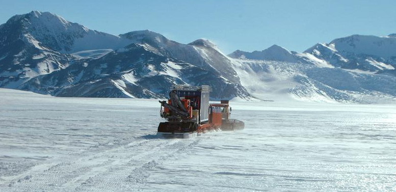
To get the equipment from Union Glacier to the Lake Ellsworth drilling site, the engineers hitched powerful tractors to sledges and skis to haul the heavy blue containers containing the drilling equipment.

.........................................................................................................................................................

More...

..........................................................................................................................................................

Soft, deep snow and concrete-hard sastrugi snow forms slowed progress, but the tractor-train reached the Lake Ellsworth drilling site in three days.


Upon arrival, an engineer fits GPS locators at the corners of the equipment storage.

Windblown snow will partially bury the equipment over the coming Antarctic winter, making it otherwise difficult to find when the science team returns in November to start drilling. (Antarctic summers are too short to transport the equipment and accomplish the drilling in a single season.)

In the coming months, this precious cargo will endure wind chills reaching minus 70 degrees C and wind gusts up to 160 kilometers per hour.
Spectacular explosions of snow, like this one detonated at the Lake Ellsworth drilling site during a previous visit, helped scientists decipher the shape of the buried lake. Researchers set off the explosions and then use seismic equipment to record the sound waves reflecting off rock, ice, water and other materials within the ice.


Seismic studies have revealed that Lake Ellsworth is a long, narrow U-shaped lake approximately 12 kilometers by 3 kilometers. It is 150 meters deep at its deepest point and covers an area of 29 square kilometers.

Ellsworth and other subglacial lakes in Antarctica can persist in a liquid state because the overlying ice provides insulation for the heat rising up through the bedrock from the earth’s core, melting ice near the base of the ice sheet.

This melted water flows into hollows and valleys beneath the ice just as it does on the land surface to form lakes. The largest and most well known subglacial lake is Lake Vostok on East Antarctica, which Russian scientists have been trying to access, so far unsuccessfully.


Small planes can land safely at the Lake Ellsworth drilling site during the summer months. Getting people and basic supplies to the site in November will not take the extreme effort of delivering the drilling equipment. But that doesn't mean the work will be easy. The team will live in tents and work on location for about six weeks.


Researchers will use a stream of high-pressure hot water blasted from the end of this high-tech yellow hose to drill through the frozen ice sheet lying above the Lake Ellsworth. The hose is a continuous 3.4 kilometers (long enough to extend from the surface down into the buried lake) and strong enough to support its own weight and that of the drill nozzle.

Other equipment delivered by tractor-train included: (1) an industrial-sized boiler to heat 30,000 liters of hot water to 90 degrees C for the drill (2) 3 large surface tanks (each with a 5-meter diameter) to store water above freezing point in temperatures as low as minus 20 degrees C and (3) several large-scale generators to provide electrical power to the drill.

Through a borehole carved using hot-water drill, the team will lower a titanium probe to measure and sample the water, followed by a corer to extract sediment from the lake. They will have just 60 hours to collect water and sediment samples before the borehole re-freezes.

The hot water drill will use and recycle the existing ice on site for the drilling fluid, minimizing the potential for contamination of the lake. All equipment was designed and manufactured to meet space-industry standards for "clean" technology.


Soon the sun will set for the last time over the Lake Ellsworth drilling site, bringing several long weeks of darkness. The engineers and scientists will return with the light, ready to make history.

The waters of Lake Ellsworth have been cut of from all light for as long as half a million years. Also under high pressure all that time, the hidden lake may have evolved unusual forms of microbial life.

If such microbes turn out to exist, they could help explain how life managed to survive during global deep freezes of the Earth's distant past -- during the so-called Snowball Earth episodes, when most if not all of the planet was enshrouded in ice. And they might up the odds that life could have evolved in other extreme environments, such as the liquid water known to exist beneath the icy surface of Jupiter's moon Europa.

Now we just have to wait and see.


10 Unknown Animals Found off Antarctica


A large survey of Antarctic life was conducted back in year 2008 by scientist all over the world. New Zealand’s National Institute of Water and Atmospheric Research played a key role in this survey. They and other researchers collected 30,000 sea creatures—many new to science—during a 35-day census in Antarctic waters in February and March. The large-scale survey was part of the International Polar Year and Census of Antarctic Marine Life programs, which study the diversity of Antarctic marine life. Of many new species discovered, prior unknown to man, we are presenting ten.
This 19 inch long creature may be tunicate or a sea-squirt, say scientists. This mysterious animal was found floating 7218 feet below water surface in the Ross Sea off southern Antarctica.
This is, what scientist say, a 9.8 inch long sea spider found in Ross Sea shelf in southern Antarctica. Cold temperatures, few predators, and high levels of oxygen in seawater could explain their gargantuan size, Don Robertson of New Zealand’s National Institute of Water and Atmospheric Research told the Associated Press.


They call it the Antarctic Octopus and it was marked as the 18th octopus species ever found. This octopus was found at the depth of 3280 feet.
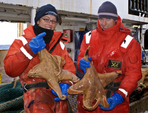
A unique type of starfish, that looks like a sack, measuring 24 inch in length was discovered by New Zealand’s National Institute of Water and Atmospheric Research on February 15, 2008.
This is a totally new species. It measures 2.5 inch across the heard and up to 39 inch in length.
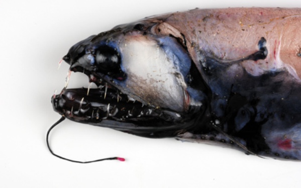
The call it stareater, also discovered in 2008. This fish has very soft skin that was damaged by the net (see pic below). The fish generates red light and lures its prey towards it. Once the prey is in striking distance, the sharp, needle-like and curved teeth give no second chance to it. The fish belongs to Stomiidae family and grows up to a size of 8.3 inch.
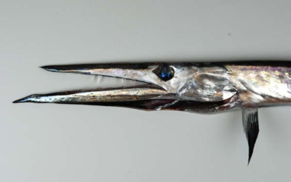
This is a new type of daggertooth, and according to scientist the southernmost daggertooth ever found. The fish has sapphire blue eyes along with a long mouth containing curved teeth to immobilize prey, clamping down and pulling back to tear through and paralyze the victim’s spine.
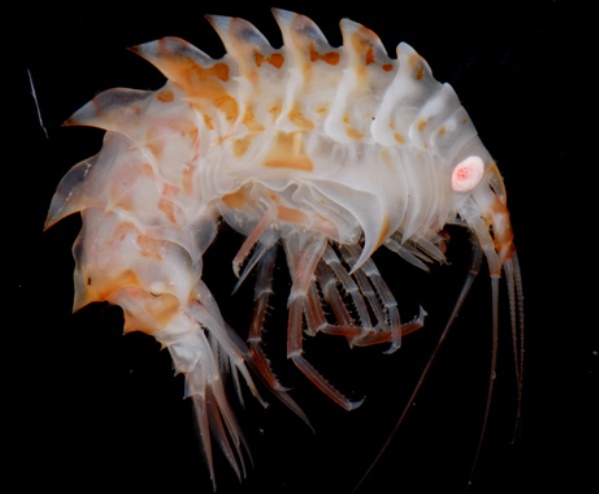
This species is called amphipod and was first discovered in year 2004 by Antarctic research ship Tangaroa. This crustacean looks like a shrimp and was collected from a depth of 985 feet from the same location in year 2008.
It is a new specie of sea pig; declared as a genus of sea cucumber (holothurians). Sea cucumbers are part of a group of marine animals that inhabit the seafloor, including sea squirts, sea stars (starfish), sea slugs, corals, clams, sponges, and urchins.
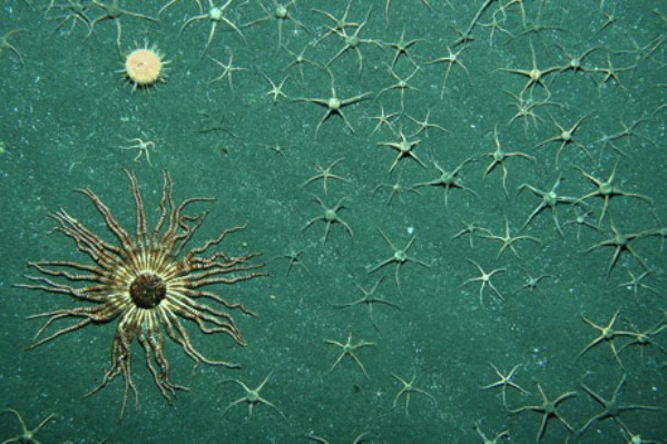
High-powered cameras photographed this sea star or a starfish of the genus Labediaster (lower left) surrounded by brittle stars on a seamount 492 feet (150 meters) below the surface of Antarctica’s Ross Sea.
   
               National Geographic
               Environment Clean Generations

The Hole is Still There


The Antarctic ozone hole, which yawns wide every Southern Hemisphere spring, reached its annual peak on September 12, stretching 10.05 million square miles, the ninth largest on record. Above the South Pole, the ozone hole reached its deepest point of the season on October 9 when total ozone readings dropped to 102 Dobson units, tied for the 10th lowest in the 26-year record.


The ozone layer helps protect the planet's surface from harmful ultraviolet radiation. NOAA and NASA use balloon-borne instruments, ground instruments, and satellites to monitor the annual South Pole ozone hole, global levels of ozone in the stratosphere, and the humanmade chemicals that contribute to ozone depletion.


"The upper part of the atmosphere over the South Pole was colder than average this season and that cold air is one of the key ingredients for ozone destruction," said James Butler, director of NOAA's Global Monitoring Division in Boulder, Colo. Other key ingredients are ozone-depleting chemicals that remain in the atmosphere and ice crystals on which ozone-depleting chemical reactions take place.


"Even though it was relatively large, the size of this year's ozone hole was within the range we'd expect given the levels of manmade, ozone-depleting chemicals that continue to persist," said Paul Newman, chief atmospheric scientist at NASA's Goddard Space Flight Center.


Levels of most ozone-depleting chemicals are slowly declining due to international action, but many have long lifetimes, remaining in the atmosphere for decades. Scientists around the world are looking for evidence that the ozone layer is beginning to heal, but this year's data from Antarctica do not hint at a turnaround.
In August and September (spring in Antarctica), the sun begins rising again after several months of darkness. Circumpolar winds keep cold air trapped above the continent, and sunlight-sparked reactions involving ice clouds and humanmade chemicals begin eating away at the ozone. Most years, the conditions for ozone depletion ease by early December, and the seasonal hole closes.
Levels of most ozone-depleting chemicals in the atmosphere have been gradually declining since an international treaty to protect the ozone layer, the 1987 Montreal Protocol, was signed. That international treaty caused the phase out of ozone-depleting chemicals, then used widely in refrigeration, as solvents and in aerosol spray cans.

Environment-Clean-Generations


Global atmospheric models predict that stratospheric ozone could recover by the middle of this century, but the ozone hole in the Antarctic will likely persist one to two decades beyond that, according to the latest analysis by the World Meteorological Organization, the 2010 Ozone Assessment, with co-authors from NOAA and NASA.
Researchers do not expect a smooth, steady recovery of Antarctic ozone, because of natural ups and downs in temperatures and other factors that affect depletion, noted NOAA ESRL scientist Bryan Johnson. Johnson helped co-author a recent NOAA paper that concluded it could take another decade to begin discerning changes in the rates of ozone depletion.


Johnson is part of the NOAA team tracks ozone depletion around the globe and at the South Pole with measurements made from the ground, in the atmosphere itself and by satellite. Johnson's "ozonesonde" group has been using balloons to loft instruments 18 miles into the atmosphere for 26 years to collect detailed profiles of ozone levels from the surface up. The team also measures ozone with satellite and ground-based instruments.


This November marks the 50th anniversary of the start of total ozone column measurements by the NOAA Dobson spectrophotometer instrument at South Pole station. Ground-based ozone column measurements started nearly two decades before the yearly Antarctic ozone hole began forming, therefore helping researchers to recognize this unusual change of the ozone layer.


NASA measures ozone in the stratosphere with the Ozone Monitoring Instrument (OMI) aboard the Aura satellite. OMI continues a NASA legacy of monitoring the ozone layer from space that dates back to 1972 and the launch of the Nimbus-4 satellite.
by "environment clean generations"

Unknown Life in Antarctic Lake


As biting winds cut through the below-freezing air around them, a team of researchers will next year seek to discover previously-unknown life by exploring an Antarctic lake that redefines the notion of "remote."

Lake Ellsworth is roughly 10 km (6.2 miles) long and is estimated to be several tens of meters deep. The reason Its depth can only be estimated is that, although it has been mapped by radar, Lake Ellsworth has never been seen by human eyes.


It lies beneath 3 km (1.86 miles) of ice, one of 387 so-called subglacial lakes in the Antarctic continent, its liquid state maintained by geothermal heat from below Earth's crust. It has been isolated from the rest of the world for perhaps a half million years, but now a British expedition is on its way to Antarctica to bring a temporary halt to the lake's isolation and, in the process, yield information about past life on Earth, possible life on future planets, and our own planet's climate, past and present.

The expedition, a collaboration between the British Antarctic Survey (BAS), the United Kingdom's National Oceanography Center and a number of British universities, will use a hot water drill to break down through the ice to the lake. A titanium probe will be lowered to take samples of water, and a corer will extract up to three metres of sediment.

Time will be of the essence: the borehole will begin to freeze almost as soon as it is opened, and within 24 hours will have frozen completely shut.

Environment-Clean-Generations
The researchers hope that, inside the sediment, they will find previously undiscovered microbial life, nurtured by the geothermal warmth and possibly quite unlike any species presently known.

"Finding life in a lake that could have been isolated from the rest of the biosphere for up to half a million years will tell us so much about the potential origin of and constraints for life on Earth and may provide clues to the evolution of life on other extra-terrestrial environments," said David Pearce, science coordinator at BAS, at a press conference to announce the expedition.


"If we find nothing (it) will be even more significant because it will define limits at which life can no longer exist on the planet," he continued.

The researchers are also hoping to find clues about the planet's climatic past, and consequently its climatic future.

"There is some evidence from outside Antarctica that sea levels were higher at various times in the last million years -- 125,000 years ago, 380,000 years ago -- but we have no evidence that the water came from the West Antarctic Ice Sheet," Professor Mike Bentley of Durham University told the BBC.

"So one of the things we're looking for in our sediment core is... marine sediments that would look very different from lake sediments."


The age of those sediments will help cast light on how long the West Antarctic Ice Sheet was able to remain stable during warmer times in the past, a matter of import as scientists seek to predict the likelihood of its collapsing, and once again causing sea levels to rise, as a result of global warming.

"If we can find out if or when the ice sheet retreated or collapsed, it could tell us what kind of conditions would lead to a West Antarctic retreat in the future," said Bentley.
by "environment clean generations"

Cloud Island Tango


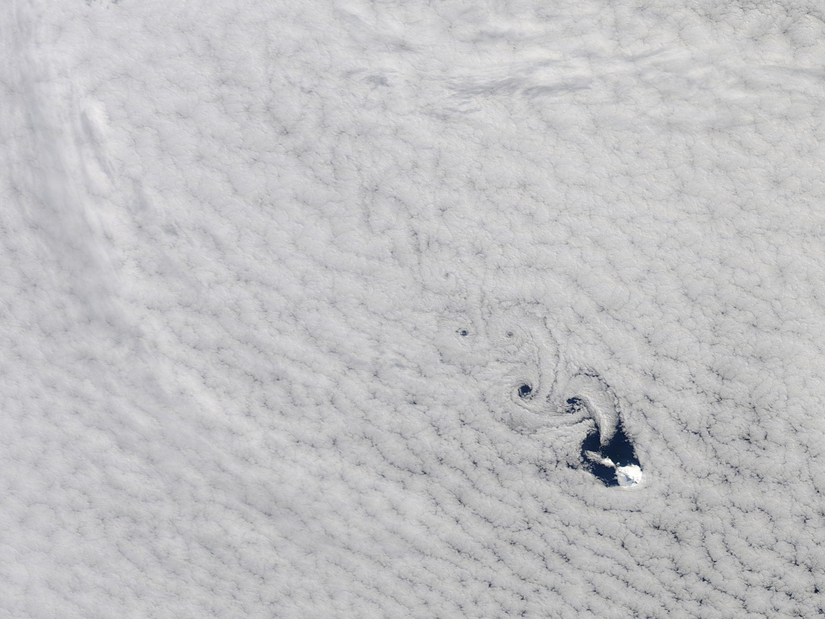
Spiraling eddies, known as von Karman vortices danced around Heard Island in the south Indian Ocean yesterday. Like a boulder in a river, the island forces the winds to diverge around it. 

The winds converge again on the other side of the island, alternating which side takes the lead in the next rotation.


The volcanic ice-covered island is the top of a landmass located between Madagascar and Antarctica. 

by "environment clean generations"

Antarctica Growing From The Bottom Up


Studies of under-ice lakes in Antarctica first alerted scientists to the capability of pooled melt-water to refreeze on the bottom of ice sheets and deform the upper layers. But this accretion ice was considered an anomaly "a weird thing that happened over sub-glacial lakes," not over the entire ice sheet, Antarctic geophysicist Robin E. Bell of Lamont-Doherty Earth Observatory

But in examining bright spots found at the bottom of the Antarctic ice sheet, Bell and colleagues have since discovered water is interacting with over a quarter of the bottom of the ice sheet - freezing and pushing the entire ice sheet up in a way that is surprisingly similar to the lake effect. "In fact, I'd forgotten the connection until last night," she said in an interview today.

The new discovery is adding an unknown dimension to the overall layer-cake growth model for ice sheets: that ice sheets gain height one layer at a time as the amount of snow falling on the top outpaces the amount of ice melting at the bottom. Bell and her team using ice-penetrating radar atop Antarctica have just turned this idea upside down.

"In some places up to half the ice thickness has been added from below," Bell and her international team of colleagues, reported in the new issue of the online journal Sciencexpress.

Working with new radars and other imaging techniques at the crown of the East Antarctic Ice Sheet, the researchers identify two mechanisms that lead to the formation of "freeze-on" ice at the base of the ice sheet. In one case, water at the bottom of ice-filled valleys, refreezes to the base of the mile-thick ice because of the water's close proximity to the overlying ice and fluid flow into the above ice matrix where instead of melting the ice around it, the convective thermal transfer of energy results in the water freezing and buoying up the ice sheet, leading to bending and modifying of the layers to the point of top layer erosion.


Along the mountain ridges that border the valleys, the team found a different mechanism occurs: the internal flow of the ice sheet forces water to flow up the mountainsides where the already super-cooled liquid experiences a reduction in pressure and quickly phase-changes into ice. In both instances, the freeze-on ice "packages" expand upward into the internal ice layers, changing their flow patterns, raising the height of the ice sheet, and causing destruction.


"The addition of 100’s of meters ice to the base of an ice sheet deforms the overlying ice upward," writes Bell. "This upwarping modifies the ice sheet stratigraphy and may impact the surface accumulation by changing the surface slope."

While the old model of top-down surface accumulation still accounts for most changes in the size of ice sheets, researchers are going to have to come to terms with the new bottom-up mechanisms. The new idea is important for climate modelers in general, but also for ice-core specialists reconstructing past climates from isotopes locked away in ancient ice.

The team writes:

"The upwarping of internal layers over accretion sites implies active interaction between basal accretion and the entire ice sheet. The accretion-induced upwarping of basal ice will move old ice to a higher elevation in the ice sheet increasing the potential of preserving very old ice. Alternatively the widespread melt required to support the freeze-on process may have destroyed the ice containing the ancient paleoclimate records. Without inclusion of basal processes, simple models of ice sheet temperatures cannot accurately predict the location of the oldest ice."

"It's an extremely important observation for us because this is potentially lifting the very oldest ice off the bed," geologist Jeff Severinghaus of the Scripps Institution of Oceanography in San Diego who was not involved in the study said in a press release. The lifting he said could either better preserve the older ice higher up in the ice sheet, or "make it harder to interpret the record, if it's shuffled like a deck of cards."


by "environment clean generations"

Antarctic In Military Plans


Australia is being urged to be ready to defend its claim to Antarctic territory in its military planning, given inevitable global competition for the continent's rich energy resources.
Antarctica is thought to have the world's third-largest oil reserves, locked away by an international treaty that preserves the territory from exploitation.

             However, a Lowy Institute report released today warns that other countries are eyeing the abundant energy reserves as technology makes it easier to access the frozen continent.

             The big oil companies are working on ways of extracting energy resources from polar regions. Last week US regulators approved plans by Royal Dutch Shell to explore in waters off Alaska.
Australia claims 42 per cent of Antarctica, a claim that is not recognised internationally. The Lowy report warns that the government must stop thinking of Antarctica as a scientific playground and treat it as a national security issue.

               It calls for military personnel to take part in ''peaceful and scientific roles'' in operations in Antarctica and to hand responsibility for the territory to the Attorney General's department, with a strong national security focus.
The international treaty covering the Antarctic expires in 2048 but the report warns Australia is lagging behind other countries that are already working to bolster their claims.

               ''China is investing in a new ice-breaker ship, ski-equipped planes and helicopters as well as extensive Antarctic astronomy and astrophysics, and is refurbishing its stations for year-round occupation,'' the report says.
             
                The report - written by an officer on leave from the Prime Minister's department, Ellie Fogarty - also criticises transport both to and from, and within, the continent.
 
                 The government's recent $46 million investment in an ice runway at Wilkins airfield was largely wasted because of a lack of aircraft equipped to land on ice, the report says, and it also recommends the purchase of a new ice-breaker.

by "environment clean generations"

Top 10 Differences Between the North Pole and South Pole


We often say, especially about people, but also some very different facts and things that "are at opposite poles." Poles differ in concept in all aspects and marks the very idea of dissimilarity. However, we often wonder if geographically speaking Earth's North Pole and South Pole are in any way special.

           Moreover, even sometimes people have difficulty in discerning between the two versions, when given in proper names of Arctic and Antarctic. For this reason, it is interesting to see that the geographical poles of the Earth are not for nothing at opposite ends of the planet, but for even more justified reasons  than a few thousand miles that separates them.

               10. Metamorphosis 

           Arctic area from North Pole, has a natural cycle of melting which about half of  sea ice disappear during summer, only to return to original size, about the surface as the U.S. during winter. 
          However, an alarming new study has shown that thick layer of ice in Greenland melts 3.5 km with such rapidity that half of it could disappear completely by the end of the century. Other studies suggest that the entire Arctic could be completely ice-free in summer within a few decades.


             In contrast, Antarctica, the South Pole, do not have the same rigorous cycles of melting ice, but retains the utmost, constant shape and size throughout the year. However, in recent years, several studies have come to discover that Antarctica is losing ice, but not by natural cyclical processes, but especially under the influence of global warming.

            Had that one day, all from the South Pole ice to melt, it is estimated that the seas and the oceans would rise slightly to 60 meters. It is noted that the ice caps melting factor in the north and south of the Earth is influenced by the fact that the Arctic is under water, which makes heating, both from the core of the planet and through the ocean currents, and basically the Antarctics is a mass of rock, little or not affected by such processes. 

                    9. Ozone Affected 

           Above Antarctic a hole has formed in the ozone layer, which spans the gap increased over time to about three times the size of U.S. land area. And above the Arctic ozone layer thinning in these very moments, but regarding North Pole a hole is still yet to occure. Of course, you can not find a proper crack where it says that there is one in the ozone layer, but this means that in that place the chemical that surrounds the Earth to protect it from solar radiation was seriously thin, even disappearing.


            Loss of ozone in the northern hemisphere are small compared to the south because higher temperatures of Arctics limiting the formation of polar stratospheric clouds that can destroy the ozone. However, temperatures in the stratosphere above the North Pole has gradually decreased in recent years, resulting in significant loss of ozone. 
  
                          8. Cold and more cold

            South Pole is much colder than the North Pole. In fact, Antarctica is so cold that snow never melts not in many parts of the continent. Region's average annual temperature is -49 degrees Celsius, making this the coldest climate on Earth's entire surface. In contrast, average winter temperatures in the Arctic is about -34 degrees Celsius and summer increases.

             
               The lowest temperature ever recorded on our planet was -89.6 degrees Celsius and was measured on 21 July 1983, at Vostok Base, located in Antarctica, near the geomagnetic South Pole. Arctic sea ice is a fact that makes the North Pole to be more sensitive to climate change.

                       7. Polar bears and penguins are not neighbors anymore  

               It is generally accepted by people, probably due to the viewing of video advertising and postcards that polar bears and penguins share the same habitat glacial. Nothing is less true. Penguins live exclusively in the southern hemisphere, especially in Antarctica, and have no natural land predators, as would certainly be the huge carnivore. 

 
               It is probably why the penguins are non-flying birds, who have adapted their wings as fins in that they serve to achieve a suite of nautical maneuvers. Polar bears, on the other hand, the largest predators on land are endemic northern species of the world and "reign" over the northern areas of the frozen Arctic Ocean, feeding on seals, walruses, and occasionally, failed whales. 

                      6. The Black Gold
             According to estimates made by the U.S. Geological Survey, under the ice of the northern Arctic Circle is about a quarter of Earth's untapped oil reserves. For this reason, Russia made a bold approach to claim a monopoly on a large portion of the Arctic in the hope that it will exploit ore deposits in the Lomonosov Dorsal , an underwater bulge beneath the Arctic Ocean , stretched over a distance of 1,800 km and that would hide up to ten billion tons of oil.


                               5. No man's land

                Despite the symbolic images of the various explorers who triumphantly planted flags in the ice at the South Pole, Antarctica continent is the only place on Earth that does not belong to anyone. There is no history of aboriginal peoples and is governed by the Antarctic Treaty, under which the territory itself and its resources will be used only for peaceful and scientific purposes.


              This is in stark contrast to a population of over four million people living within the Arctic Circle, in a few small settlements, and cities such as Barrow, Alaska, Tromso, Norway; Muramansk and Salekhaard, Russia . On Antarctic's territory are only occasionally stationed  people on missions of research and numerous scientific basis.

                        4. A lot of ice 

             The planet's southernmost continent has easily 90% of all Earth's ice, ice encompassing about three-quarters of the Earth's freshwater. This has fed for some idea to cut and move icebergs to extinguish the thirst of excessively dry areas. 


                  In fact, Prince Mohammed al Faisal of Saudi Arabia even took a moment to consider the plan to deploy an iceberg 100 million tonnes of Antarctica and transports in the Arabian Peninsula. By comparison, the north is characterized by a much less quantity of ice than the south pole. 

                          3. Continent vs. Ocean 

                 The Arctic is practically a frozen ocean surrounded by land. In contrast, Antarctica is a continent in itself, rock and soil types of relier as mountains, valleys and lakes, surrounded by ocean.

  
                  Ironically, socially and politically, the Arctic area, made ​​completely of ice only, intersecting influences and manifestations of territories such as Canada, Greenland (part of Denmark), Russia, Iceland, Norway, Sweden, Finland and the United States of America . As noted earlier, the South Pole, far removed from any continental mass, the territory is not governed by political entities, not colonized or not even inhabited by Eskimos. 

                           2. Polar vortex

                 Geographic poles of Earth are characterized by what is called "polar vortex", a major cyclone that occurs near the vertical limits of the planet. Polar vortices on Earth are located in medium and high levels of the troposphere and stratosphere. They surround the polar areas and are part of what is called "polar front" - the boundary between the polar and climate that follows, south, north, respectively, in both hemispheres. 
For the Antarctic polar vortex is more pronounced and more persistent than the Arctic.


                   This is because land masses concentrated at high latitudes of Northern Hemisphere, atmospheric Rossby waves give rise, contributing to calm the vortex. Meanwhile, the polar vortex of southern hemisphere is much less disturbed and therefore above the Antarctic was created the hole in the ozone layer, as described above. 

                            1. Magnetism and deposits 

                     Because it is a continental mass, beneath Antarctica you can find minerals like: nickel, gold, silver, platinum, iron. Obviously, nothing of this sort for the Arctics. Regarding Earth's magnetic poles one of them is about in the planet's north and the other one in the south. When we refer to the magnetic north pole, this reference relates to the homonymous geographical position, even if the north pole of Earth's magnetic field is actually in the south and south pole magnetic field is in north.

             The planet’s magnetic poles do not coincide with its geographic poles because the magnetic field of the Earth is changing. Unlike the geographic poles, the magnetic ones actually move, and this could be considered a common feature of the two poles. The difference is that the magnetic north pole (the south of the magnetic field) is no longer located right in the Arctic region but is moving towards the East at a rate of 55-60 km every year. The magnetic south pole (the north of the magnetic field) still overlaps Antarctica, but is also moving westwards at a rate of 10-15 km per year.


 by"environment clean generations"

Related Posts Plugin for WordPress, Blogger...

Search

Custom Search

 
Design by Wordpress Theme | Bloggerized by Free Blogger Templates | coupon codes