Environment-Clean-Generations

Environment-Clean-Generations
THE DEFINITIVE BLOG FOR EVERYTHING YOU NEED TO KNOW ABOUT THE ENVIRONMENT YOU LIVE IN, WITH REFERENCE TO LIFE, EARTH AND COSMIC SPACE SCIENCES, PRESENTED BY ENVIRONMENTAL ENGINEER DORU INDREI, ENVIRONMENTAL QUALITY AND ENERGY SPACIALIST
"Life is not about what we know, but what we don't know, craving the unthinkable makes it so amazing, that is worth dying for." Doru Indrei
Custom Search
Showing posts with label island. Show all posts

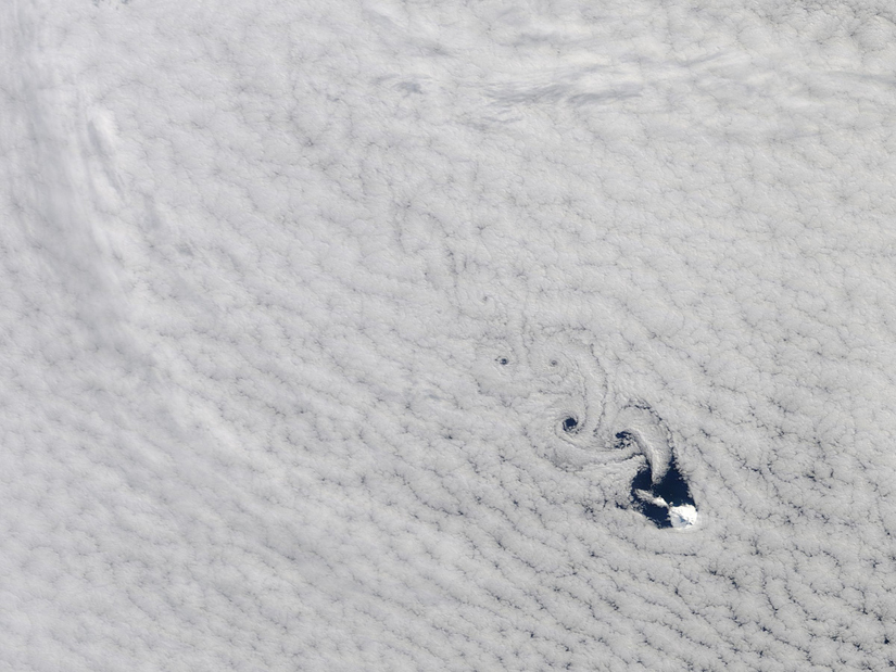
Cloud Island Tango


Spiraling eddies, known as von Karman vortices danced around Heard Island in the south Indian Ocean yesterday. Like a boulder in a river, the island forces the winds to diverge around it. 

The winds converge again on the other side of the island, alternating which side takes the lead in the next rotation.


The volcanic ice-covered island is the top of a landmass located between Madagascar and Antarctica. 

by "environment clean generations"

Future Mars Colonists Terraforming By Studying Darwin's Methods


Ascension Island Charles Darwin's artificial forest captures moisture from clouds that drift over the volcanic peaks on Ascension Island. Google Earth. The father of evolution apparently played God with a tropical ecosystem 160 years ago, and the results could inform future experiments to terraform Mars, botanists say. 
 
The BBC recounts how Charles Darwin helped build an artificial forest on Ascension Island, one of his subjects of study from his trips on the HMS Beagle. Today, the island is home to species of plants that would not naturally co-exist. Darwin and his friends put them there, and nearly two centuries later, their grand experiment is living proof that we can transform natural environments.

Originally used as an outpost to keep an eye on Napoleon in exile, Ascension Island, between South America and Africa, was a busy Atlantic waystation in Darwin’s day. It had meager fresh water supplies, however, so Darwin and his botanist friend, Joseph Hooker, set out to change things.

The BBC interviews Darwin biographer David Catling, a professor at the University of Washington-Seattle, who says he believes Darwin decided to build a lush “Little England” on the volcanic island after visiting it in 1836.

Darwin’s friend Hooker explored Ascension a few years later, and in 1847, Darwin convinced Hooker to get his father -- director of the Kew Gardens -- to send trees, hoping they would capture rain, prevent erosion and reduce evaporation.

Beginning in 1850 and continuing each year, ships brought an assortment of plants from botanical gardens in Europe, South Africa and Argentina, the BBC says. By the late 1870s, eucalyptus, Norfolk Island pine, bamboo, and banana had taken hold.

Today, Ascension is home to a cloud forest that would have taken millions of years to evolve naturally, according to Dave Wilkinson, an ecologist at Liverpool John Moores University in the UK.

It’s proof that humans can build a fully functioning ecosystem simply through trial and error, he said. As the BBC reports, the same principle could be used in future Mars colonies: “Rather than trying to improve an environment by force, the best approach might be to work with life to help it find its own way.”
Intelligent design, indeed.

Greenland Is Melting


The trawler's crew could scarcely believe their eyes. They had seen icebergs before as they fished off the coast of Labrador, but never anything quite like this, what was described as "a dazzling white ice island five kilometres long and alive with mountains, valleys, brooks, waterfalls, ponds and seals."

                 A short video (embedded at the bottom of this blog post) that they took of the "floating ice city" was for a while trending on YouTube, and for good reason: Although the clip is short, it is long enough to demonstrate the immensity of the expanse of ice stretching in front of the camera.

                Two years ago, I was communicating every day with another ship that was monitoring that same expanse of ice; but back then, the ice was where it was supposed to be - as part of Petermann Glacier in northwest Greenland, one of the northernmost glaciers in the world. The video at right shows the glacier still intact.

                 I was coordinating a tour of Greenland and the ice edge near Svalbard for Greenpeace, which was providing its ship Arctic Sunrise to researchers as a platform to study the impacts of a warming world on a changing Arctic. The tour began off Petermann, where the crew worked with a science team led by Jason Box of the Byrd Polar Research Center at The Ohio State University, who had been watching Petermann closely for years.

                  This video explains the work that Box and colleagues were doing on Petermann; but the big, sexy take-home messaging was that, as Box said, "Petermann glacier disintegration has been progressing since year 2000", a development that was expected to climax with the calving of an ice island approximately 100 square kilometers in area. Alas for us, despite several weeks of waiting, during which the researchers deployed time-lapse cameras and other monitoring equipment - and even, as depicted in the photograph at top, kayaked across part of it, towing ice-penetrating radar to measure the glacier's thickness - the large crack across the glacier did not split asunder and the ice island did not break away.

                  The following year, however, it did, sending a chunk of ice three times the size of Manhattan into Nares Strait, from where it has slowly been making its way south, calving smaller islands as it enters warmer waters, with those smaller pieces themselves breaking up into additional chunks. All the segments are continuing their southward journey, monitored closely by Canadian authorities. The ice island that the trawler encountered was off Black Tickle, Labrador. 
            
                  The other day, I was talking via Skype with one of the crew who had been on board the Arctic Sunrise in 2009, who had gazed at the glacier, flown over it, and walked across it countless times. Even though we expected that ice island to break off at some point, and even though we knew that when it did so it would, because of its size, be far south before it melted, it was still quite sobering to see the video, two years later, of that same piece of ice so many hundreds of miles from where it had been.

"We could probably recognize landmarks, given a satellite image of it," he mused. "It kinda blows my mind."


by "environment clean generations" 

Related Posts Plugin for WordPress, Blogger...

Search

Custom Search

 
Design by Wordpress Theme | Bloggerized by Free Blogger Templates | coupon codes